From the ice age to the Crystal Palace: a micro-history of London’s Great North Wood

sydenham-hill-wood-coxs-walk-oaks-november-2013-daniel-greenwood-1

Introduction

For seven years I volunteered and worked for London Wildlife Trust at Sydenham Hill Wood and Dulwich Wood in south-east London. These woods are the largest remaining remnant of what is known as the Great North Wood. During that time I soaked up a lot of information, conducting my own research into the cultural and natural history of the area. I led guided walks and gave public talks on as many areas as possible related to the natural and cultural history of the area. I have condensed much of that information into this blog post. An earlier version of this post was handed out to attendees to walks and talks on behalf of London Wildlife Trust. My knowledge of the entire Great North Wood, which Sydenham Hill and Dulwich woods are the largest remnant of, is not strong enough to ‘write a book on’, but I have posted about the history of One Tree Hill, another remnant, before. This is my whirlwind around these precious woods from the time of glaciers to present day.

5483272214_1e150dfd1c

Wildwood: 12,000 BC

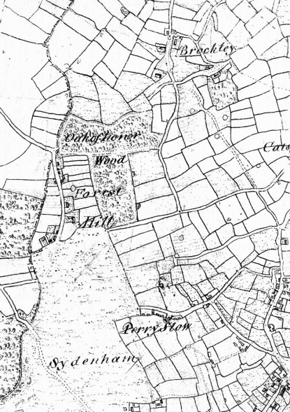
The Dulwich woods are a collection of remnant ancient woodlands in south-east London, made up of Sydenham Hill Wood (a nature reserve managed by London Wildlife Trust), Dulwich Wood, Low Cross Wood, Hitherwood and Dulwich Upper Wood. The woods are generally known as Dulwich Woods or Sydenham Woods by local people, sometimes influenced by whether they are from the Sydenham side of the ridge in Lewisham or the Dulwich side in Southwark.

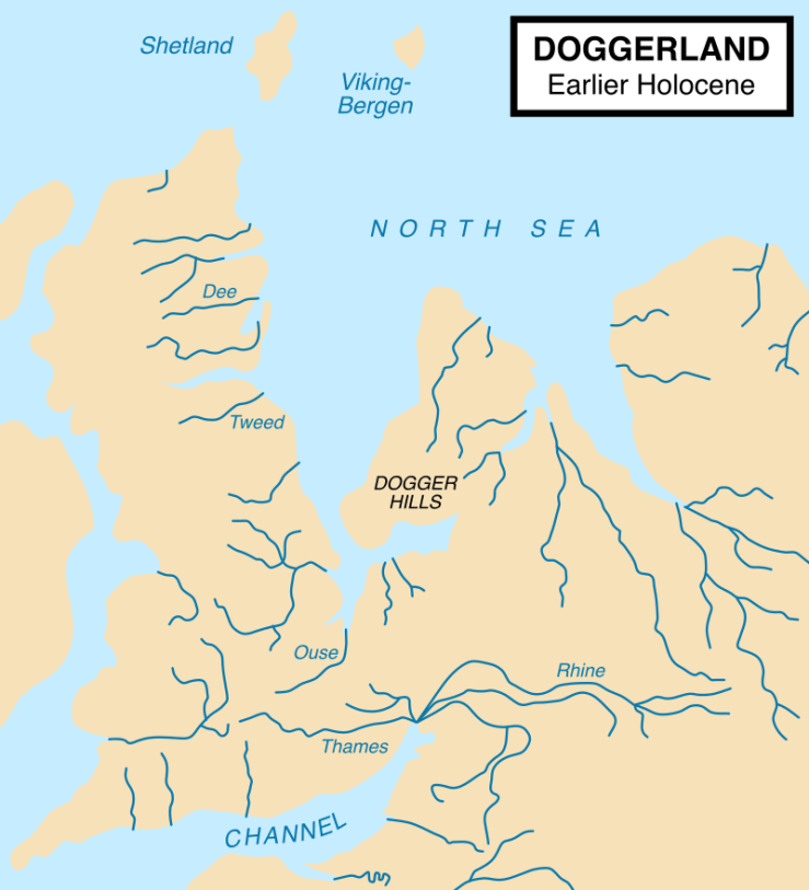
Parts of the Sydenham Hill and Dulwich woods are thought to have been covered by woodland since the first trees returned to Britain at the end last glacial period, some 14,000 years ago. The end of the UK glaciers came when climate change led to a period of warming. This warming melted the great ice sheets that had spread across the Northern Hemisphere and sat north of London. As the ice melted, the ensuing water created lakes, rivers and wetlands and the rocky debris carried by the retreating ice carved open valleys and new landscapes. While what is now the British Isles remained connected to continental Europe, the Thames was a tributary of the Rhine in Germany. Today, off Sydenham Hill runs the Ambrook stream, a tributary of the Effra, a ‘lost river’ which still enters the Thames at Vauxhall.

800px-doggerland.svg_
Doggerland (via Wikipedia)

Trees spread by seed on the wind or with the assistance of jays (‘scatter-hoarding’), red squirrels and small mammals. This ‘wildwood’ provided habitat for returning wolf, bear, lynx, elk, beaver, otter and deer, along with birds, mushrooms, insects and wildflowers. Hunter gatherers followed their prey into this more hospitable landscape and made settlements in the woods by clearing trees and creating more open areas to live in.

By 6,500 BC the ice had melted to such an extent across Europe that sea levels rose and flooded the low-lying plain between Britain and Europe, creating the British Isles as islands physically separate from Europe. By the Neolithic period (4,000 BC) the wildwood had been much reduced and people exploited nature’s resources like never before. The growth of farming, developed in the Middle East and spreading through Europe, meant that populations were increasing and the hunter gatherer’s way of life was disappearing.

Peckarmans Wood
The coppices known as Peckarmans Wood in the 1800s, what is now Dulwich Wood

The Great North Wood: 500-1500 AD

The Dulwich woods are the largest remaining part of the Great North Wood, the early name given to what was left of the wildwood in south London by the Anglo-Saxon period (AD 410-1066). These remnant ancient woods straddled the clay ridge running from Honor Oak to Beulah Hill. The Romans had come and gone (AD 43-410), forging new roads and making use of the Great North Wood’s resources of oak, hornbeam and hazel, mining its clay for brick and pottery. It was the ‘north’ wood because it was north of Croydon, a thriving medieval market town. The Anglo-Saxons also wanted to differentiate between the Great North Wood and the Weald, another extensive woodland landscape that sits between the North and South Downs, running as far as Hampshire in the west and Kent in the east.

It was only later that placenames related to the woods began to appear: Selhurst and Brockley being two good examples. The use of ‘hurst’ at the end of a name indicates a wooded hill, possibly a place where timber was removed or used to some specific purpose, whilst ‘ley’ means a clearing or settlement in woodland. ‘Brock’ is the old English word for badger, an animal which still clings on today in secrecy. Names like Forest Hill are deemed artificial, though it likely refers to the wooded ridge of Sydenham Hill. The Great North Wood was no forest at all, unlike the New Forest, Ashdown Forest or Epping Forest, it was not created for the purpose of a royal hunting ground. ‘Norwood’ is arguably the single truest reflection of this ancient landscape. Penge is London’s only Celtic placename, meaning ‘the end of the woods’.

Tree-felling
Woodland workers removing the buttresses of an oak before felling. Coppice poles can be seen in the background

Woodland industry

The Dulwich woods have been patrolled or cared for by a warden since as early as the 1200s. One of the key industries was tanning, where the oak bark was peeled off and taken to the tanneries and soaked in with hides to make leather. From the 1600s to the mid-1800s it was the second largest industry in England. The tannery at Bermondsey was the destination for much of the woodland produce. Oak trees were harvested after some 80-150 years to build ships, therefore allowing the British military to ‘rule the waves’ and put the ‘Great’ in Great Britain, as some people say. Britain’s oaks ships were the upper hand in battles waged at sea against the Spanish, the Dutch and attacks against the Chinese mainland.

Britain’s isolation as an island protected it from land invasion after the Norman Conquest of 1066 and the end of Anglo-Saxon rule. The harsh strictures of Forest Law and later royal protections for woodland meant that up until the Napoleonic Wars, the oak resources in England enjoyed some stability. To make one oak ship today would likely require the entire felling of Sydenham Hill Wood and Dulwich Wood combined, some 25 hectares of woodland. Needless to say there is no appetite for such. We should also remember that the Dulwich woods were never ‘forest’ in the Norman term, despite what the word means today.

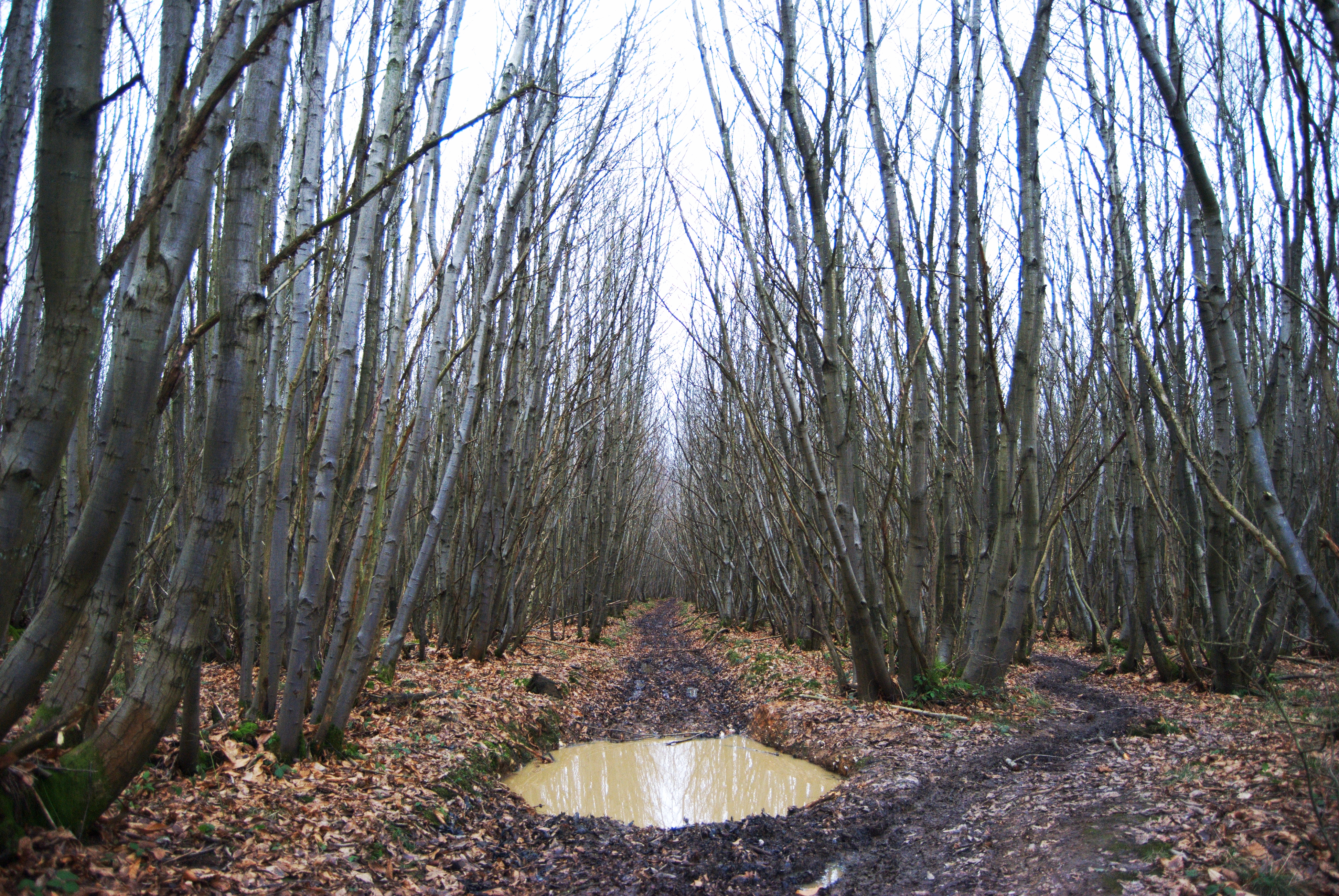
Colliers were charcoal burners who lived in the woods, an industry of huge importance to London and local villages. Trees like hornbeam were coppiced or cut down to their stump to form multi-stemmed trees that could be harvested for wood indefinitely. The wood was stacked into a kiln, in this case made from clay, and burned to create charcoal. Other woodland products included poles, posts, bavins (bundles of twigs for firewood known also as faggots), birch twigs for brushes and withies (long, thin hazel shoots).

Image result for margaret finch
Margaret Finch in Norwood

The Norwood Gypsies and other local characters

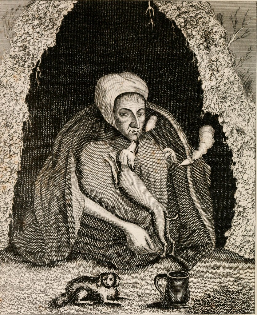
One of the more interesting local placenames is Gypsy Hill, in reference to a camp of ‘gypsies’ who were famed for their presence there. Margaret Finch was known as ‘queen of the gypsies’ and was visited by the Victorian middle classes to have their fortune told. It is said she was so ‘decrepit’ she could only ever crouch. Other notable dwellers within the woods included Samuel Matthews, the hermit who lived in a cave dug near where the Cox’s Walk footbridge is. He was murdered in 1802 for his wealth collected as a jobbing gardener in nearby properties. He was said to be a popular local figure but his murderer was never convicted.

7006407747_b2cb89906e
Samuel Matthews (Steve Grindlay)

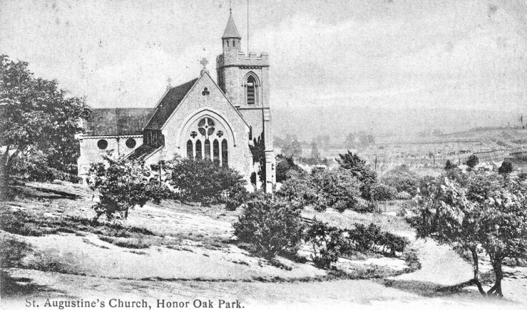
Local literary figures include William Blake, whose vision of angels took place on Peckham Common, possibly after a visit to the Dulwich woods in the 1760s (and maybe the ingestion of some magic mushrooms?). At the bottom of Cox’s Walk the poet Lord Byron studied at Dr. Glennie’s above what was then the Grove Tavern pub in 1799. John Ruskin walked in the woods during the time of the Crystal Palace, lamenting the place of the building on the wooded ridge.

File:Crystal Palace Great Exhibition tree 1851.png
An elm tree enclosed inside the Crystal Palace in 1851

Enclosure: 1720-1830s

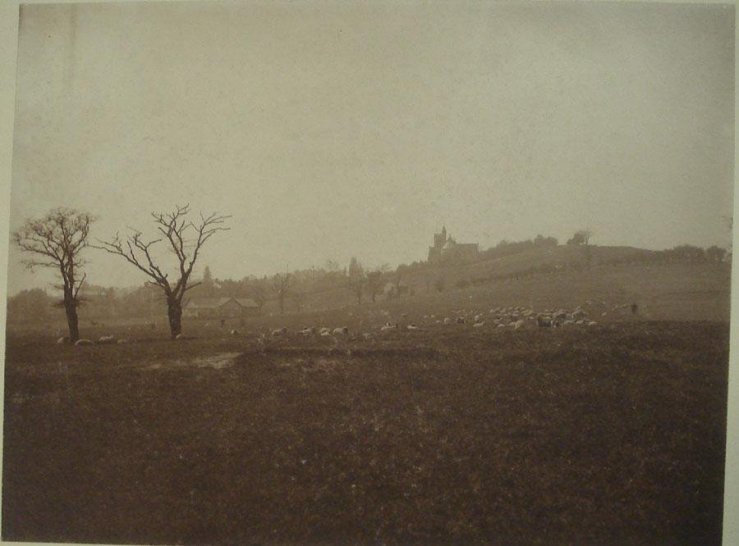
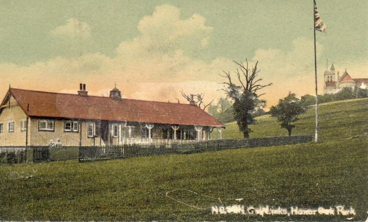
In the 1700s Acts of Parliament were put in place to remove common lands from public ownership and allow their sale and enclosure. Locally affected commons included Westwood or Sydenham Common which covered much of what is now Forest Hill, Dulwich Common which is best represented by the Dulwich and Sydenham Hill golf course, Dulwich College playing fields and Dulwich Park, and Penge Common which was enclosed as Penge Place and is now Crystal Palace Park. Sydenham Hill Wood did not exist at this time but was a series of coppices spread across the Dulwich woods in the form of Peckarmans Coppice, Ambrook Hill Wood, Lapsewood, Kingswood and Vicars Oak Coppice.

This seismic political shift has created the townscape and suburbs we see today in London. It is only through hard-fought planning battles, philanthropic foresight and good fortune that any of London’s commons still exist. The enclosures put in place the eventual development of the coppices known today as Sydenham Hill Wood. By the 1730s Cox’s Walk had been cut through an area known as Fifty Acre Wood from Sydenham Hill in order to attract visitors from the Sydenham Wells to the Green Man Tavern at the junction of Lordship Lane and Dulwich Common, site of the Dulwich Wells where natural springs rose. By the early 1800s Fifty Acre Wood had been grubbed out for farming, now forming part of the Dulwich and Sydenham Hill golf course and the Marlborough Cricket Club fields.

Related image
The Hoo on Sydenham Hill, now returned to woodland in Sydenham Hill Wood

The Victorians: 1800-1900

Immense change came to Sydenham Hill and Dulwich with the construction of the Crystal Palace in 1854. In 1865 the Crystal Palace High Level railway was cut through the Sydenham Hill coppices. It took millions of people to the Crystal Palace’s Great Exhibition until its eventual closure in 1954, after the Palace had burned down in 1936. The Cox’s Walk footbridge was constructed over the railway line to allow the continued use of the pathway. The Crescent Wood tunnel, which plugs the southern end of Sydenham Hill Wood, was closed to the public in the 1990s due to Health & Safety concerns and later it was designated as a registered bat hibernation roost due to the presence of brown long-eared and pipistrelle bats using the crevices in the old brickwork.

In the early 1860s the construction of large villas along the Great North Wood ridge running from Forest Hill to Beulah Hill began. The coppices of Sydenham Hill Wood were separated into smaller plots of land and sold on 99-year leases by the Dulwich Estate. The residents of these houses were wealthy, with some houses accommodating more than 20 people, in this case servants for the families. Lapsewood House was home to Charles Barry Junior, the designer of newer Dulwich College, North Dulwich Station and St. Peter’s Church next to Cox’s Walk. Another house, Beechgrove, was lived in by Lionel Logue in the 1930s and ‘40s, the speech therapist characterised in The King’s Speech. A garden folly was constructed with Pulhamite, a material patented by James Pulham, in the grounds of Fairwood. The cedar of Lebanon which still remains was in the grounds of the Sydenham Hoo and can be seen as a sapling in Victorian illustrations of the garden.

Wood anemone
Wood anemone is an indicator of ancient woodland in the Dulwich woods

The returning wild: 1950-present day

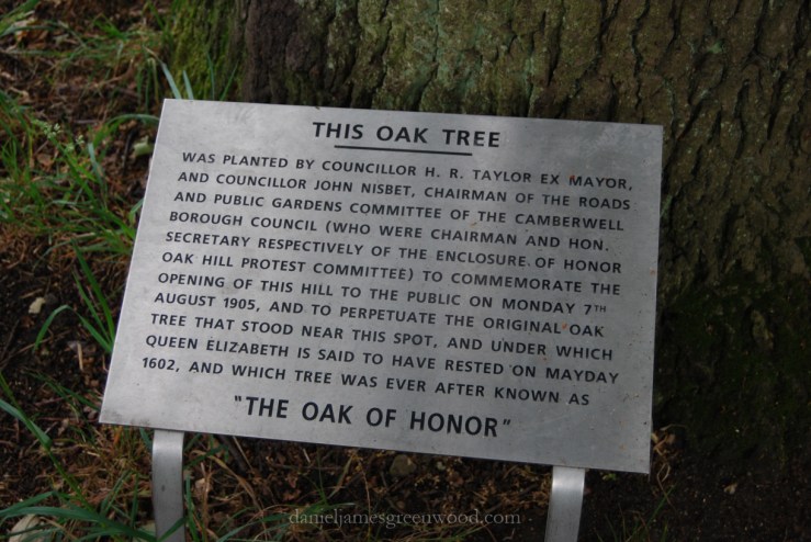
The advent of the First and Second World wars brought irreversible change. Traditional woodland management was extinct and the Victorian boom was over. Many of the houses were nearing the close of their leases in the 1950s and by 1980 all of them had been demolished. Local people had been entering the grounds of the old houses and the disused railway line since the 1950s. The landscape was returning to woodland as trees began to retake the gardens and railway cutting with no intervention taking place from either the Dulwich Estate or Southwark Council. In 1981 London Wildlife Trust were formed and by 1982 Sydenham Hill Wood had been designated as a nature reserve. This was after fraught and long lasting battles involving Southwark Council, the Dulwich Estate and local people spear-headed by London Wildlife Trust, the Dulwich and Sydenham Societies and the Horniman. London Wildlife Trust are now lease holder of Sydenham Hill Wood and each of the former mansion grounds running along Sydenham Hill. Today the Trust, Southwark Council and the Dulwich Estate are working in harmony to protect the natural heritage of the Sydenham Hill and Dulwich woods with the support of volunteers.

The woods are experiencing historically high numbers of visitors, with data suggesting that over 100,000 people step through each year. It is a critical time for people to access and understand our green spaces due to the dislocation many feel from nature and the impending threats of climate change and species loss. Sydenham Hill Wood is one of the most important green spaces in London for the story it can tell about human impacts on the land, challenging our concepts of what is natural and normal. Its 10ha has seen it all, surviving through all that our species has thrown at it in over 10,000 years of human history. It bears those scars but its wildness remains. Who knows what it will see in the next 100 years.

Further viewing:

The Dulwich Society archives

Mapping the Great North Wood – video


Tracing the footsteps of the first Europeans in the Pálava Hills

The Pálava Hills

In September 2017 I visited the Pálava Hills in south-eastern Czechia, close to the border with Austria. Beginning at the Archeopark Museum in Pavlov, where an exhibition of some of the most important Paleolithic finds ever were on show, and finishing in the town of Mikulov, I try to capture the world of our hunter gatherer ancestors, the Gravettians.

I take the road up towards Děvin, a hill where Děvičky, a ruined 13th century castle faces out towards Austria. From the surrounding vineyards sounds the booming of gas cannisters designed to deter flocking starlings from eating the grapes fruiting at this time of year. A church stands in the heart of Pavlov, and a small murmuration of starlings swoops and morphs in search of a perch. The faux-shotgun fire is working. I pause at a bench overlooking Dolní Věstonice, and north of this a village now flooded after the damming of the river Dyje. Long before the flooding, some 30,000 years ago, a tribe of people known as the Gravettians kept watch from the hills with small encampments and fires. When herds of reindeer and roaming mammoths entered the valley they lit fires to signal that the time to hunt had arrived.

Down in the village of Pavlov the Archeo Park Museum protrudes from the grass bank like fragments of chalk, perhaps an attempt to reflect what’s kept inside – some of the most revealing human artefacts ever to be found. In this area of the Czech Republic, now known as Czechia, evidence has been found to show that hunter gatherers, the Gravettians, lived in these hills approximately 30,000 years ago, disappearing when a climactic cooling took place 8,000 years later.

Pavlov phone pics djg-3
The Venus of Moravia (copy)

The items on show in the exhibition include a copy of the Venus of Dolní Věstonice. This sculpture is of a woman with large, elongated breasts and wide hips. Its meaning is unknown but it suggests some ritualistic celebration of the female form and fertility. There are many such small sculptures to have been found but more often broken into pieces, possibly smashed as part of a ritual. The Venus was found almost complete. Yet more intriguing is the presence of a fingerprint said to be that of a child between the age of 7 and 15. Was this a gift in mourning from a father or family member to a child after the death of their mother?

Whatever the explanation is, a ceramics culture appears well ingrained in the world of the Gravettians, something unknown until the discoveries were made here in Moravia. The exhibition, lodged deep at the foot of the Pálava Hills, brings to life the human history of this Carpathian outcrop. Here I learned about the megafauna that both predated and sustained the human tribes in what will have been a cold and unforgiving landscape, one that has much changed from that of the Paleolithic hunter gatherers. In Dolní Věstonice, flooded after the damming of the Dyje, only the village church remains above water on a small island, along with the skeletal remains of trees that drowned with the intentional flood. Red-footed falcons, ospreys and other birds of prey are said to perch on those dead branches. To look out from this point is to see an industrialised landscape of crops and vineyards.

Palava djg-84

The Gravettian hunter gatherers used wood for specific purposes, and they had the ability to prepare flints and stones for weapons. The use of wood suggests an understanding of woodland management, at least how trees will grow and which species is most useful for a specific task. The permanent settlements of the Gravettians were constructed from timber. Ash and hazel were surely the preferred material for a spear, if they did indeed grow in the area at that time, as they produce straight and flexible poles unlikely to snap upon impact, therefore able to be picked up and chucked again. Both can be split by the flints and other sharp tools they had with ease, similar to their use in making early wooden hay rakes. As for stones or flints, the Pálava Hills are part of the Carpathian massif, formed in the Mesozoic, no more than 250 million-years-ago, from the residue of the oceans that once washed here. Limestone is simple to quarry, as a sedimentary rock it is younger and subtler that igneous or metamorphic rocks. But the colder conditions of the time would have made that difficult, therefore the animals they hunted would have been crucial in all the resources they provided.

Pavlov phone pics djg-9
Tools including primitive saws made from flints and shards of rock
Pavlov phone pics djg-6
A necklace made from mammoth bones

The river Dyje runs south of Pálava, joining with the Morava at the border of Czechia, Slovakia and Austria. These two great European rivers are tributaries of perhaps the greatest, the Danube. It is thought that the first Homo sapiens to enter Europe 42,000-years-ago did so by following the Danube and its floodplain. It was rich in resources: water, wood from floodplain forests, fish and meat, rocks and stone, and pelts from animals present in its riparian margins. This behaviour has resulted in the creation of many European cities along major rivers, my home city of London and the Thames being a fine example. The Dyje’s braided channels and meanders are where the Gravettians based in the Pálava Hills found their flints and stones for tools, weapons and crafts. Here they found fish and beavers for pelts. Thankfully beavers are still in the area, despite the attempts of local Moravian fishpond owners to eradicate them.

Into the woods

The first break from the town is into Děvin’s woods, where a steep track worn by feet and running water swerves through multi-trunked trees: small-leaved lime, elm, hornbeam, ash. These are old coppice stools, trees once cut down, their wood harvested for firewood or some other need. Now they are overgrown. These woods hold plants that are not found in many other places, including rare bellflowers, and birds such as black woodpecker, hawfinch and golden oriole. The woods will not have been the same 30,000-years-ago when the Gravettians lived here, so much colder was the climate and closer the northern European glaciers. At this time Middle England remained under ice.

Worse still for the vulnerable hunter gatherers, wolves and lions would all have hunted from the cover of woods and the caves held within. But wolves were a key prey for hunter gatherers in Pálava, with their bones commonly found near former settlements. The Gravettians lived in tepee-like tents made from wolf and other animal skins and pelts, meaning that hunting was a crucial part of their lifestyle. Mammoths would have been the key prey in housing a tribe because of their size and the rich bounty of materials that could come from them. Other megafauna included arctic fox, woolly rhinoceros – a species which beggars belief – elk, reindeer, horse, deer, ibex, chamois and maybe bison. Now only the red fox, chamois, ibex, deer and wolf remain from this array of wonderful animals. Wolves inhabit Czechia, Slovakia, Poland and are moving into Germany, Belgium and even the Netherlands.

Reaching the light beyond the woods I take the choice of a lower route with more cover. This rain is the thin, fast-falling, soak-you-through kind. The path is pale with the calcium of the chalk. The slopes from the hilltop are dotted with scraggy scrub, some are charming little oaks, a species once more common in Czechia, before a move to German forestry ethics of pine and spruce took hold. Ironically these are the trees that will have sprouted from this rocky outcrop some 30,000-years-ago.

The grasslands the scraggy oaks stand in are muted and yellowed, but in season they are some of the richest around, with uncommon plants, many tied to these limestone hills, and a rich abundance of moths and butterflies. They are a rare habitat known as steppe grassland, a remnant of the open landscape that the Gravettians entered into. It’s likely that these meadows hold more species of butterfly than all the British species combined. The Gravettians of Pálava had problems with less colourful insects. They were known to use red dye to deter the mosquitos that plagued them here in the Dyje floodplain. Even today mosquitos are considered a major problem in the area, exacerbated by attempts to dam the river near the Austrian border.


These grasslands tell a further story of the Gravettians, one which says much about the world we live in today. Work by Italian archaeologists has led to the discovery of microscopic plant matter on rocks used in the form of a pestle and mortar. The Gravettians may have been grinding down grain or other plants to create pastes or other foodstuffs. This technique has a domestic hint to it, suggesting that the farming or Neolithic revolution of 4,000 BC was not the explosion it is sometimes said to be. Perhaps the Gravettians took with them from the Middle East and Africa an understanding of how to do more than forage, also to use certain plants to produce pastes and even soups.

Evidence suggests the role of the already present Neanderthals, Homo neanderthalensis, is not completely recognised in how our own species adapted to life in Europe. There is evidence of hazelnuts being ground down into a paste by ‘British’ hunter gatherers to use on the move, a source of energy that suited their lifestyles. Our Paleolithic ancestors were not dim cave people banging their heads against the wall; their lives were short, their strength and fitness great, their understanding of natural resources far keener than the average person today. Who out there could ever hunt a wolf with hand tools?

Walking on, the path dips in and out of more coppiced woods, the stools extending in length and thus in age. Chlorophyll has already begun to fade from the leaves, creating a faint glimmer of yellow in the woods. It’s a welcome shift from the grey, misty day. I pass down into more woods where flocks of marsh or willow, great, blue and long-tailed tits join with nuthatches to feed in a rain-drenched glade. The rain falls hard and I sit under a picnic watching it pour down, the birds still flocking, calling, feeding. It’s a time to regret not getting the bus and instead confining yourself to a march over open hills, with the mist stealing away views.

Palava djg-40
Mikulov castle with Austria on the horizon

Memories of sunnier times

In 2013 I woke up in a tent on an old farm and walked from Mikulov at dawn over the Pálava Hills, ending up at Dolní Věstonice. It was July and vital to begin at first light to avoid the highs of a Moravian summer. Hence the images used here don’t quite correlate to the reverse I experience now: rain and cold. In 2013 the hills were being tramped by families from Czechia, Poland, Austria and Slovakia enjoying summer holidays, today I am unlikely to see anyone at all before the villages and eventually the major town of Mikulov. Back then golden orioles sang from trees and colourful bee eaters lined up on telephone wires. Now these African migrant birds have returned south to avoid the European winter. There is a heavy sense of absence in this place.

On that sunny day in July 2013 the vista of Austria was clear, the end of Czechia marked by the reversion to thin strips of farmland and crops, white wind turbines spinning on the horizon. Mikulov castle stood clear against an Austrian tapestry of fields and small woods. The castle (‘zamek’ in Czech) itself has relevance to the Gravettian treasures found in Pálava. During the Nazi invasion of Czechia (1938-45) the fascists wanted to continue the work of the Czech archaeologists. Many of the artefacts were kept in Mikulov castle. During a battle to remove the Nazis from Pálava, the castle burned down and many important items were lost. Thankfully the Venus was being kept in Brno and survived the devastation. Never forget that war is about more than an atrocious loss of human life, it so an attempt to erase certain histories and cultures, even if it was not the desire of the Nazis on this occasion.

I pass over Stolová hora where horses graze against the desolate horizon. Mountains of cut scrub are piled alongside the path, cleared to allow the wildflowers and their co-dependent butterflies and other insects to remain. In July I saw crested-cow wheat and sparkling shows of stellarias in these meadows. Down from the hills once more, I walk alongside the road with sweeping views of endless monocultural crops, a throwback to Soviet collectivisation that has led to huge environmental difficulties: biodiversity loss, soil erosion and aquatic pollution from pesticide run-off. The average field in Czechia is 500hectares. Many come here to photograph the undulating fields and valleys of Moravia, known as ‘Moravian Tuscany’ in places.

At Klentnice a bus sweeps by: wet and muddy I trundle on. Cyclists ride in the opposite direction towards Pavlov, the leader speaking English in guiding tones to two Australian friends who listen closely. In 2013 I noted viper’s bugloss, poppies, thistles, knapweeds, scabiouses tended by red tailed bumblebees and painted ladies. ‘The colours of the living strike against the black, crumbling tarmac edge’, said the notes. Not today.

Czechia 2017 lo-res djg-353

Before turning up onto Turold, the final hill of this three peak challenge, I stop to photograph a small-leaved lime tree lodged between houses and parked cars. It is a natural monument, even located on the Czech map service I’m using on my phone. These trees are commonly planted across eastern and central Europe. They are the linden tree, one of the first to colonise after the most recent glacial period 14,000-years-ago. The small-leaved lime is the Czech national tree. The Gravettians would have had a use for this tree, perhaps eating its leaves and making tea from its flowers.

The path curves around Turold, with a view of the hills I have just walked, stretching away in the rain beyond vineyards. Turold is a series of limestone outcrops heavily wooded and cut internally by networks of caves. The rock faces are where the eagle owl nests, Europe’s largest, a beast that preys on birds as big as buzzards and ravens. The caves contain colonies of lesser-horseshoe bats, one of Europe’s most threatened species. Of course, all this is only clear because of information boards, for which a visitor should be grateful. Perhaps the best information of all comes from the edge of Turold and the beginning of Mikulov. Here stands a wooden shelter selling refreshments, it’s a bat bar. Faded laminated photographs are stapled to the wooden panels showing images of inside the caves and bats roosting. Sadly, the bat bar is hibernating.

Palava djg-4

Of castles and campfires

Arriving back in Mikulov the question comes to mind: could those Paleolithic Gravettians ever have dreamed that a building as grand as Mikulov castle might stand here looking south towards the great river Danube? Living in tents of animal skin, carving small sculptures of rhinos, mammoths and images of deceased mothers and sisters, what futures did they dream of? The castle is grand, indeed, but it is not dissimilar to the hunter gatherers keeping watch from the hilltop – you only have to note the structure on each of these hills to realise that we share the same desire for protection from threats appearing on the horizon.

Distant the Gravettians may have been in time but in practice and creativity we are the same, but for the fact that their strength, stamina and practical skills are likely to have far outweighed our own today. We still carry their fears of insect bites, of megafauna that might hunt us, though we are without that very same megafauna, projecting those fears onto the closest thing we have, imagining that our countrysides are the domain of great unknown beasts.

The thing that I take from the knowledge of our ancient ancestors is a need to remember our origins, not in nationalities or ethnicity, but our place in nature. The Gravettians faced everyday difficulties which we do not, but there can be no doubt that we share the same need to create, to move freely, to use the resources we have wisely. The Gravettians are thought to have left Moravia because of climate change, exacerbated by the micro-climate of the Carpathians. They moved south for a time out of necessity but then came new generations who went on to establish our great European cities and institutions. These ancient people we patronise and know so little about, we are indebted to them.

Oaks of London: The Honor Oaks

OTH oaks-5

This post is part of my oaks of London project

For the past five years I have been searching hedge lines, woods, parks and boundaries for the undulating mass of an old oak. This search has not taken place in the English countryside, instead the border of the London boroughs of Southwark and Lewisham. The southern towns of Southwark were once the parish of Camberwell and its boundary with Lewisham still supports centuries-old oak trees that were the previous markers between old Camberwell and Lewisham. Along with the Dulwich Woods and One Tree Hill, these trees are the strongest ties to the much diminished Great North Wood.


map-01377-750
One Tree Hill (centre left) when it was ancient woodland in 1799

The Great North Wood

The Great North Wood was a landscape of woods and commons that stretched from Selhurst to Deptford. It was worked over centuries for its timber and underwood (sessile oak, hornbeam and hazel, mainly) for ship building, tannin extraction and charcoal burning. Its origins are in the wildwoods that spread after the end of the last glacial period 10-12,000 years ago at the start of the Holocene. The oaks remain where other species have disappeared as they are tough, long-living (sometimes 800 years in open land) and are of great use to our species. The Forestry Commission approximates that London’s trees are worth £43billion in their environmental and amenity value. Oaks are some of the most important. Their carbon storage capabilities should be remembered by those controlling planting regimes in cities today.

5360366289_d78b913930_b

This old image (likely early 1900s) shows what One Tree Hill’s western slopes were like. The earlier map, dated 1799, shows that One Tree Hill was an isolated ancient woodland. It once connected with the Dulwich Woods which skirt the left hand side of that image, and spread even further before humans began managing the woods. That could have been thousands of years ago, however. The Dulwich Woods are very likely several thousand years old.  There is no woodland at all but plenty of shrubs, likely including gorse and hawthorn. The landscape swelling into Lewisham shows much of south London’s old landscape was farmland. The boundaries of the farms were marked by old oaks.

OTH pollards-4

Pollarding

One of the first mistakes made by those (myself included, of course) looking for old trees in the landscape is to head for woodland first. The oldest trees are usually living in isolation in what has longest been open land. The great Oliver Rackham told us that ‘ancient woods are not the place to look for ancient trees’. The best trick is really to get an old map, compare it with a current one and see if there are any clear boundaries where trees may have been planted or perhaps wild trees maintained as standards. Sometimes the old maps show trees dotted along the edges. The image above is a pollarded English oak (Quercus robur) at the entrance to One Tree Hill on Honor Oak Park. The tree is actually in the grounds of the Honor Oak Allotments and a line of similarly old oaks can be found running up alongside it.

OTH pollards-5

This oak, one down from the previous, has clearly been pollarded (c.1900s) and is now swamped by other trees. Logic says that pollarding it again and removing some of the surrounding growth would allow the trees to re-balance and go on living indefinitely, but experimental pollarding taking place in Epping Forest suggests otherwise. Lapsed beech pollards are known to die when pollarded again. These oaks may be so unused to management that pollarding them will kill them off. We may have to accept that these landmarks of the Great North Wood have a limited time left.

OTH oaks-1

The Oak(s) of Honor

One Tree Hill is a good case study for remnant Great North Wood sites as it was open land until the mid-20th century but was woodland on the north-western slopes up until the 1840s. Today it is returning to woodland having been largely managed through non-intervention, bar access works and hedge planting, by the Friends of One Tree Hill and Southwark Council.

OTH oaks-2

One Tree Hill gets its name from the single English oak (pictured) which was replanted in 1905 when the hill was reopened to the public after a battle to save it from becoming a golf course. 15,000 people conducted a mass trespass on 10th October 1897 to challenge the Honor Oak & Forest Hill golf club’s attempts to fence and enclose the hill.

1239142979_e33df99e5b_b

The previous Oak of Honor was thought to be much older and was a boundary tree for the old vice-counties of Kent and Surrey. It was also the edge of the Honour of Gloucester’s land. The idea is that in 1602 Queen Elizabeth sat under the tree and was thus honoured thereafter. Today the Oak of Honor is the most obvious tree to seek but by no means the oldest. I love that it has so influenced local place names. An old black and white photograph of the former oak (the church building can just be seen in the top right) gives the sense that the oak was not so old, perhaps only a few hundred years before it perished. This tree was destroyed by lightning in 1888.

4445212937_157026c2d7_b

To the right is the oak of Honor when it was only a decade old. The open landscape of early 20th century Honor Oak/Forest Hill is filling up with housing. The tree cover on the hill was largely hawthorn scrub, as can be seen behind the caged oak.

Wildlife

It’s worth remembering that though we are fixated by neat and tidy trees in urban areas, often for safety reasons, that oaks provide habitat for a great number of species. The Oak of Honor in September 2015 held many knopper galls, the protective case for a gall wasp (Andrus quercuscalicis), and oak apple galls.

OTH oaks-1-3

The top of One Tree Hill is an excellent spot to find butterflies in spring and summer because it is open and sunny. This speckled wood (Parage aegaria), one of the contemporary Great North Wood’s most common butterflies, was enjoying some September sunshine on the great tree’s leaves.

OTH nut-1

The winter months provide ample opportunity to find nuthatch (Sitta europaea) which is often tied to oaks because of the invertebrates it forages from the bark and the old woodpecker holes it nests in. It makes a neat mud ring around woodpecker holes to make the entrance smaller and more protective for its young.

OTH PH-1

The purple hairstreak was the first ecological record at One Tree Hill when it was mentioned for the first time in the 1766 publication The Aurelian by Moses Harris. This overlooked butterfly was ‘commonly taken in plenty in Oak-of-Honour Wood, near Peckham, Surry.’ It’s one of the insects promoted by conservation groups in the Great North Wood, a good indicator of long-term woodland cover, especially at nearby Sydenham Hill and Dulwich Woods. The purple hairstreak is only usually seen by those straining to look up at the canopy or those lucky enough to stumble across one when it’s down and dazed on the path.

OTH oaks-3

Secret oaks

The oldest of One Tree Hill’s oaks is likely to be this lapsed pollard (whereby a tree is cut higher up – coppice is cut at the base – to prevent grazing animals eating regrowth) growing on the path that runs adjacent to Brenchley Gardens. I’ve seen a photograph somewhere of the tree isolated in open land, with Peckham’s farms rolling down to what is now Peckham Common.

OTH pollards-1 
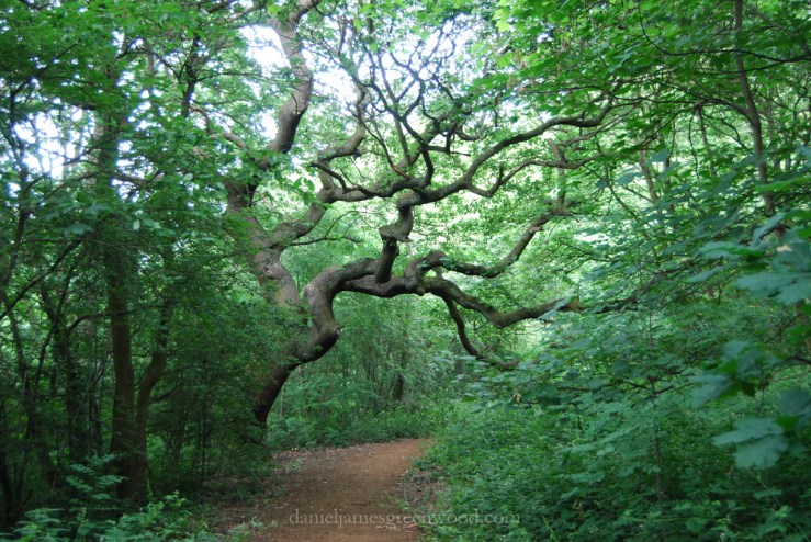
The tree, seen here on the right of the photograph (its lean exaggerated by the distortion of my 10-24mm wide angle lens) is competing with the seedlings that have likely fallen or been stashed by grey squirrels (Sciurus carolinensis) and members of the corvid family, especially jays (Garrulous glandarius). You could suggest that the new woods of One Tree Hill are products of its old boundary oaks, where the dominant species is oak. Recent research has uncovered how important crows are in establishing new oak woods across the northern hemisphere.

OTH oaks-1-4

One of the lower limbs is rotting nicely and providing habitat for slime moulds and small mushrooms, whether this is a bonnet (Mycena) or a parachute (Marasmius), I couldn’t tell you. The life that old oaks can support adds to the tree’s immense amenity and ecological value. Oaks typify the anthropomorphic but no less accurate notion of trees being ‘accommodating’ to many species.

Next door to One Tree Hill and its allotments is Camberwell New Cemetery, a more authentic remnant of Honor Oak’s open landscape of the past 200 years. One boundary, otherwise planted with Lombardy poplar (Populus nigra ‘Italica’), has two old English oaks. One has been hollowed out, possibly after being struck by lightning or affected by human damage. It’s an example of trees as habitat, something which people are generally uncomfortable with at first, especially with fungi as they think the tree is dying. In August 2015 the hollowed oak had the fruiting body of what I think was chicken-of-the-woods (Laetiporus sulphurous). Oak supports many insects and also fungus. The oldest oaks you are likely to find will be dependent to some degree on mycorrhizal relationships with fungi. Fungi can also help the oaks by removing bits of deadwood that may otherwise add extra weight to the tree as it ages. Some species are necrophratic and will eventually kill a tree because they ‘take more than they give’.

OTH sheep

On first thought I was suspicious that the two oaks seen here might be the same two on the allotment-cemetery boundary. This is a photo from the 1920s that shows Camberwell New Cemetery and the Honor Oak Recreation Ground as open land being grazed by a flock of sheep. Evidently the sheep were used to keep the grass short for golf, or maybe also as a way to support a local farmer. The golf club house can be seen in the distance. The building on the hill in the distance is St. Augustine’s Church (1872-3). These two trees are too far away to be the same as those above, they are probably instead some of the black lines that can be seen in the distance. Note also the absence of any tree cover on One Tree Hill beneath and to the right of the church. Between the mid-1800s and this point, there ancient woodland had been well and truly grubbed out, possibly even some old boundary trees going as well. Today, this would be unacceptable.

1239140483_779d98bd92_b

Instead, I think this image of the old golf club house exhibits the line of oaks. These oaks look to be dying back, possibly because of the impact of building the club house where the trees’ roots were. The distance between St. Augustine’s and the line of trees is one parcel closer than the previous image (Steve Grindlay).


Essay: The threat to English ancient woodlands is a challenge to our collective sense of place

Blean Woods RSPB just outside Canterbury in Kent

I live in an area of London that was once covered by a stretch of woodlands, commons, meadows and wood pasture that was called the Great North Wood. It was not the continuous wildwood which some argue had covered parts of England totally after the melting of the ice 10,000 years ago, before humans began to cut the trees down. It was known as the Great North Wood because it sat north of Croydon, a large market town fringed by chalk downlands which are not so hospitable to the kind of woodlands dominating the land to the north on London clay, namely hornbeam and sessile oak. On London’s open downlands livestock grazed and rabbits were bred for their fur and flesh. The wild but manipulated landscape of the Great North Wood would have stretched all the way north to the Thames at Deptford (where timber could be exported on ships or turned into ships), cutting off at Penge (Celt for ‘the end of the wood’) and slithering down a little like the continent of South America to Selhurst. Many of the placenames in the locality echo the woodland past, the history of its woodspeople, or the woodsman (which Ben Law neatly points out means ‘wood hand’ rather than excluding women). This can be seen most clearly by Norwood, derived from the name of the landscape itself, as well as Brockley which could describe a human settlement where badgers were notable. The ending of ‘ley’ generally means a clearing or settlement next to woodland. Honor Oak is a pointer to the Oak of Arnon Wood, a slab of probable millennia-old woodland which is now embellished by the Local Nature Reserve One Tree Hill, where the Oak of Honor stands in the form of an English oak replanted some 100 years ago after the site was saved as a public open space by dissenting locals in 1896. The lack of a ‘u’ shows that this is of the old English spelling for honour, the language taken to the Americas by settlers some centuries ago and now seeming somewhat alien or incorrect.

The Great North Wood was not merely one of endless woodlands or of wildwood, it was a landscape that humans were a part of and dependent on for their livelihoods. Some of the woodlands which remain today such as One Tree Hill and Sydenham Hill Wood, have shown that they were at times more open, that larger trees stood singularly with commoners grazing their livestock on the grasses and herbaceous plants underneath the shade of trees like elm, oak, hornbeam and ash. This before the advent of the enclosures when commoners had their rights removed through an Act of Parliament, a series of events which define the landscape of my hometown to this day. As recently as the 1950’s one of the Great North Wood’s most unaffected remainders, Dulwich Wood, was grassier and more open whereas today it is darkened by holly and an array of other trees such as hornbeam, ash, hazel and rowan. Still, the ancient remnants of the Great North Wood hold colonies of wood anemone, dog violets, wild garlic and other plants which indicate continuous woodland for at least 400 years.

Wood anemone indicates 400 years of continuous woodland

One of the main ways that people would have earned a living was by inhabiting the woodlands. Charcoal burning was one of the most common sights and vocations in the Great North Wood. They were known as the colliers, their presence indicated by Collier’s Wood in Wandsworth, beyond the western fringes of the catchment. Hornbeam was ‘coppiced’ on a cycle of 10 or so years, the trees cut at about 20-30cm, a vigorous regrowth the next year created multiple stems and thus an eventual greater crop to be burned and sold to blacksmiths and those needing intense heat to fire their craft. Other trees coppiced were hazel and ash, with hazel especially important for its usages for fencing and walking sticks. Sessile oaks were allowed to grow tall and true for their timber and the tannin residing in the bark. But coppicing is not necessarily as destructive or exploitative as it may sound, as when coppicing was more common – before the advent of coal and the increase in imports of cheaper fossil fuels from abroad – the Great North Wood’s coppices were home to populations of nightingales and nightjars, not least at Penge Common (now covering the famous Crystal Palace Park and the town of Anerley) where locals were said to visit at night to listen to the nightingale song, and there is some anecdotal evidence that the nocturnal music fuelled an increased birth rate. Coppicing allowed light into woods, enriching the herb layer of these woodlands, giving life to wildflowers such as dog violet which then supported the silver washed and dark green fritillary butterflies, as well as beloved primroses, now diminishing from the English landscape as ancient woodlands and hedgerows have been grubbed out and poisoned over time, feverishly in the latter part of the twentieth century.

A renewed interest in coppicing has given a new sense of purpose to our woodlands

This brings me to the issue of woodlands and biodiversity offsetting, a scheme mooted by the Department for Environment Food and Rural Affairs (Defra) as a way to mitigate losses to wildlife from development. In recent times the former Transport Secretary Justine Greening advocated the ‘transplanting’ of ancient woodlands which are in the way of the proposed High Speed Rail 2 line intended to travel from London to Birmingham and then north to Manchester and Leeds in a final ‘Y’ section. More recently Environment Secretary Owen Paterson has confirmed his liking for proposals to clear ancient woodlands and plant 100 trees for every ancient tree that is lost. Both of these proposals fall flat after only a little research or, dare I say it, consideration. As Oliver Rackham puts it in his totemic ‘Woodlands’, ancient woodlands are not the place to look for ancient trees. Paterson is mistaken. What he is looking for might be something like Penge Common, or one of the other commons now gone from the Great North Wood. It is now only really in wood pasture or ancient hedge lines that you can find ancient trees. In ancient woodlands it is the landscape and ecosystem which is ancient. Paterson sells himself as a man in-tune with nature and the countryside, posing by fence posts and boasting of keeping badgers as childhood pets. His rhetoric suggests he is out of his depth.

Ancient woodlands are not the place to look for ancient trees.

Today ancient trees are loved, most in estates or arboretums where they are prized for their age and ‘wisdom’. In ancient woods, such is the diversity of life, many trees succumb to fungal infection, because fungi is another aspect of an ancient woodland. The life of fungi is in the soil, the mycelium, to be exact. The mycelium is, in some ways, the life force of woodland, passing nutrients back and forth between trees and soil, a little like the information superhighway I am using to publish this article. Fungi is as vital to human existence as trees, often described as ‘the third force’ after animal and plant life. So too are certain species of wildflower, insect, mammal and bird depend on ancient woodland ecosystems. We are talking about an environment that takes many hundreds of years to develop. This is why HS2 Limited’s desire to dig up the ancient woodlands (33 ancient woodlands are directly affected according to the Woodland Trust) and transplant them elsewhere is the thinking of people who should not be entrusted to decide on infrastructure projects that endanger ancient woods or natural landscapes. ‘Moving’ a woodland would not mean a big family moving from a big house to another. It would be the same as a city removing its hospitals and replacing them elsewhere without foundations or power to run the building and its infrastructure. The real point is that ancient woodlands, biodiversity, nature, these are hindrances to short-term economic gain, and in many ways, to this government’s ideological assault on the environmental sector. Biodiversity offsetting, on this level, is something those of us who love trees, woodlands and nature cannot accept or allow to occur.

One Tree Hill’s Golden Jubilee beacon attracted 600 people in 2012

But what does this have to do with the Great North Wood, or of woodlands that were not necessarily valued for their biodiversity and wildlife but instead for their produce? The failure of biodiversity offsetting is its inability to recognise the need that human beings have for woodlands int he environmental sense, the importance of access to green and ‘natural’ spaces. It fails to see the importance of place, let alone wildlife or biodiversity. Worst of all it is a signifier of our failure, not just that of politicians, to see that woodlands present an opportunity for a more simple and healthier existence than the one presented to many in England today. In Ben Law’s ‘The Woodland Way’, he outlines just how far the English have moved away from their ‘forest dweller’ existence, an era that would have dated back to the Great North Wood. Woodlands offer us sanctuary, food, the resources for infrastructure, a place for real learning – wood carving, coppicing, construction, food growing, fencing, tool use – and countless creative industries. Many people express the sense of belonging offered by time spent in woodlands. The woodland sell-off plans panned (but possibly remodeled to fit biodiversity offsetting) caused outrage in the UK and led to a 500,000 strong petition being delivered to the Prime Minister David Cameron. This was a worrying time – we learned then that this government do not hold the best interest of our woodlands at heart – but the public were able to send a unified message. The sell-off was not acceptable.

Biodiversity offsetting fails to acknowledge the importance of place

The Great North Wood is a case in point for people standing up for their woodlands in the shape of One Tree Hill, saved from enclosure by ‘the great agitation’, as it is known locally, when thousands rioted to protect it from enclosure. And then there is Sydenham Hill Wood, saved twice by local people, London Wildlife Trust and the Horniman Museum from plans for it to be developed for housing. I wonder how the battles would have gone if biodiversity offsetting was in place in those, both very different, times. Our woodlands are only safe when they are loved, ‘used’ and valued by local people. Sadly, it would appear that our woodlands are not merely under threat from invasive species and disease, but also from the short-termism, bravado and lack of thought from authority figures like Paterson. Though some woodlands have been around for more than 1000 years, even in a place like urban south London their national fate is at the whim of individuals looking only as far as 12 months into the future. But that is only the case if people do not speak out and challenge the ecological illiteracy of ancient woodland offsetting. Consider that the next time you walk through a wood in spring, when its wildflowers, birds and insects are flourishing around you. That place is only safe because you and the community value its sense of place.

North Downs diary: the endless scene

Sweet chestnut coppice

King’s Wood, Kent, December 2012

The piles of birch trunks tell us that this chalky fringe of King’s Wood has recently been coppiced. The heartwood glows golden against the black, brown and grey of a winter’s afternoon. The paths are boggy, holding the tracks of boots and the tyre marks of cyclists and scramblers. Large ditches appear at intervals, home to trees and dead wood. A Soakham Downs poster a little way back identified these as chalk pits dug in old times to extract the chalk from the soil. The chalk was then spread in the fields – what once would have been woodland – to fertilise the soil, left to weather under sun and rain.

Further ahead the woodland opens in earnest, endless tracts of sweet chestnut coppice climbing into the sky. A brown puddle reflects the bare branches. Sweet chestnut provides the nuts we like to roast at Christmas, as well as forming the most economically viable form of coppicing in today’s market. The poles are cut after about five or six years and split down the middle to make chestnut paling, a type of fencing used in parks and nature reserves up and down the country. It’s another aspect of the Roman’s botanical legacy – they brought it along with them. The vertical slant of the branches is interrupted by a movement of four legged animals crossing our path in the distance. Our talking pauses as we watch an endless trail of deer move from right to left, disappearing into the trees. One of them was all white and it sticks in my mind like a puncture. We make our way towards Chilham, stopping briefly to search amongst these overgrown trees for walking sticks. We listen to the multiple stems tapping together as the wind steals through, some trees creaking. This a sound that in the endless scene of coppiced trees we mistake for shrill and distant calls of people.